Quantcast
Jump to content

Recommended Posts

Posted

Does anyone use GPS, whether on a device or app to record their ATV trail rides? I have been thinking about a section where our members can upload let's say a .gpx file and share their rides on a google map for others to see where there are riding areas. Not sure if this is something of interest or how much it would be used, so just trying to get an idea.

Importing routes from files like xml, lmx, tour, freshroute, gpx, kmz, kml

  • Like 2
  • 2 weeks later...
Posted

I use a GPS for trail riding, with the software I use it has a nice feature I can geotag photos I take while riding.

I also have taken several trail maps and converted them so they can be displayed on a GPS while riding. Mainly the larger

PA state forest trail maps and AOAA's map.


Mike


Posted

I have been using basic Garmin auto and handheld on our quads and even the boat. For most part they work well and get you back to your starting point. We have the Ram 1 inch ball mount and that works real well. I use the ram mount to hold our Sony Action Cam and the Phone to monitor the picture. We also use a spot satellite tracking device on a ram mount. During our trip to SD Black Hills I have seen people using a tablet there, So we downloaded the trail map for there on our old Samsung tablet and that worked great. Another trip to NH we were looking at the bikes using the fishing plotter on the bike from Lowrance, it was cool but lots of cash and bulky. I have a 7 inch lowrance on the boat and was thing of moving it around but it would need a bigger ram ball and just not worth the added cost. I do not ride in deep enough water with the quad that I also need to find the fish.

Posted

Great info, was wondering if anyone can attach a copy of a .gpx or other file after exporting, if you can export. I'd like to see what the output is and test some display for a possible trails section.

Posted
On 10/14/2016 at 8:00 AM, Admin said:

Thanks for posting. What type of software are you using and are you using it through an app on your phone? Can you export your trails?

The software I use is called "expertgps" it is not free, but I use this program for a lot of my other hobbies so its worth it for me.

I do not like using a phone for GPS tracking as the sensors are not as good as a real GPS unit and it puts a heavy toll on the battery. The tracks and data can be imported/exported to almost any format I choose and I can transfer them to my phone or tablet.


Posted
On 10/18/2016 at 7:25 AM, quadmaniac said:

I don't use GPS but wondering if anyone is using a specific ios or android app on their phone while riding to record trails.

I use android, some of the apps I have I use are "Open GPS tracker" (free) "Journey tracker" (free)

Openstreets Android "OsmAnd" (pay) but there is a free version, "US Topo Maps" (pay)

Posted
On 10/16/2016 at 2:23 PM, Scubasonic said:

Yes I use a Garmin Montana 650T when I ride.

Scubasonic, that Garmin Montana 650T that looks like no joke based on the features. I see some refurbished ones for under $400 but new the lowest I found was $499 on Amazon. Is the GPS accuracy of these handhelds vs a phone app that makes them better? I don't have one and am just curious.

Found on Garmin:

https://buy.garmin.com/en-US/US/into-sports/handheld/previous_models_handhelds/montana-650t/prod75228.html#gallery-dialog


cf-lg.jpg

Posted
On 10/21/2016 at 4:33 PM, Admin said:

Thank you for sharing your file. :D

Yes they are very accurate much better then a Cell Phone, That is a great price it was $600 when I bought it I don't go ATV riding without it.  I do geocaching as well and with over 30,000 finds it is the GPS to own I have 2 of them.  I don't go riding without it.

Posted
Yes they are very accurate much better then a Cell Phone, That is a great price it was $600 when I bought it I don't go ATV riding without it.  I do geocaching as well and with over 30,000 finds it is the GPS to own I have 2 of them.  I don't go riding without it.


Would you mind sharing what you are doing by geocaching? Are you saving your rides or sharing the geo locations? Is it part of a network share? How does that work? Don't mean to be ignorant, haven't really researched it.

What are you primarily using it for, to find your way back when riding?


Sent from my iPhone using Tapatalk
Posted

I use a regular auto GPS, currently using a Nuvi 52LM on a Ram mount with VVMapping maps. The downside is that it's not waterproof but I put a plastic bag over it when there's any chance for it to get wet. The topographic information is not as good as a purpose-built off-road unit like the Montana. But the screen is more readable and best of all, they're cheap. I got the one I'm currently using for $35 on eBay. If it dies, I'll buy another one. I can buy a whole bunch of them for the $600 it would cost to get a new Montana. I'm planning to use it on the snowmobile this winter, it'll be interesting to see how it holds up there.

There are some good videos on youtube about using an auto GPS off-road.

Posted
13 hours ago, Admin said:


Would you mind sharing what you are doing by geocaching? Are you saving your rides or sharing the geo locations? Is it part of a network share? How does that work? Don't mean to be ignorant, haven't really researched it.

What are you primarily using it for, to find your way back when riding?


Sent from my iPhone using Tapatalk


Geocaching is a online Treasure hunt with caches all across the world to get a better understanding go to www.geocaching.com and check it out I have a RAM mount on both my ATVs w/power and when I am out riding I can download the whole trail system where I am riding for example I went to Bend Oregon and downloaded the whole riding area 312 Miles of trails and it would show the Geocaches along the way so I would stop and get them combing 2 sports, the Montana is waterproof and has a very large screen.  Sure you can use a car GPS, and put a bag over it, but I'm not into Cheesy, make shift crap.  I believe in the right tool for the right job.  Also allows you to see where you have ridden, comes in handy for night riding when all the intersections look the same, you can just follow your crumb trail back to your truck.

Posted

I use AllTrails and GPS Kit apps on iPhone.  They are accurate enough for the mountain biking, road biking, hiking and ATV riding that I do.  Right now I'm liking GPS Kit better, but AllTrails has some new "pro" (paid) features I'm wanting to check out.

  • 1 year later...
Posted

I use a Garmin Oregon 450, it was about $450 back in its day, but its been reliable and does resist water, One feature I like is it can display custom maps. Using the software I mentioned above, I can take a map and calibrate it to make it GPS accurate. The picture shown here is actually a historical USGS map I calibrated and uploaded to the unit. I am following an old railroad that no longer exists. The map shows the railroad (map is from 1947) so I can follow the old grade even when parts of it are grown in now.

I can also take maps of ATV trails and do the same.


On a charged set of AA batteries, it will last about 12 hours.

Mike


100_7464 (Medium).JPG

  • Like 1
  • 2 weeks later...
Posted

I use a Garmin InReach Explorer coupled via Bluetooth to the Earthmate app on my android phone. This give me the topo map that matches the Delorme Maine Gazetteer maps (a must have for the Northern Maine woods)

The main reason is that 80% of where I ride has no cell phone coverage.  I'm typically 20 miles or more away from the nearest tower. and the InReach give me satellite Text message, email and 911 capability. Also if I'm riding alone it drops a waypoint every 10 minutes so my wife (or others I give the URL to) can check the Garmin web page map and see where I am. After 12 hours on the trails I've used about 10% of the battery life.


  • 4 weeks later...
Posted

I have used a Garmin Etrex Legend in the past but th screen got screwed up without me abusing it other than some adverse weather conditions.  Also, I forgot to remove the handlebar mount from the trike before I sold her years ago.  I used it to record riding distance, speed, time etc...  I have been thinking of getting a new GPS unit for future travels. 

Here is a ten year old video of me riding with th Etrex Legend mounted on th bars of a 1985 Honda ATC 200X trike: 

https://www.youtube.com/watch?v=ylBmeDrZY9o 

Here is a longer video of me, on th same trike, using the same GPS unit: 


Posted
22 hours ago, CJ River Rider said:

Recorded ride at AOAA in PA. Recorded on an older Garmin 400c that I bought at the time for the jetski. Just downloaded topo map as the unit came with a marine map preinstalled.


AOAA only provides their maps for using a gps is via the maprika app on phones, which I always do not like to use on the trails. (the phone that is) They do have paper maps at the trailhead, but I was able to get them to send me a PDF of the trail maps and now calibrated them so they can be uploaded into a GPS unit.  Here they are attached.

The western map is off on the left side, based on actual tracking data I have from riding the trails. I did my best to compensate, but changing to aerial view, shows the problem is their map, the tracks are right on the money with aerial view.


For other PA riders, I have calibrated maps for some of the state trails like Whiskey Springs, Bloody Skillet, Denton Hill (Potter County), and Dixon Miller. If anyone is interested, this website allows me to upload KMZ file.


AOAA - East.kmz

AOAA - West.kmz

AOAA - East with overlay.jpg

AOAA - West Aerial with overlay.jpg

AOAA - West with overlay.jpg

  • Like 2
  • 3 weeks later...
Posted

I usually use an IOS program called "Go Map!!" for marking new trails. Accuracy is better than other programs I have tested, but still nowhere near as accurate as even a cheap dedicated GPS for some reason. The convenient part is the app will make a GPX file that is directly uploadable to OpenStreetMap, which I find really handy for backwoods navigation. That site is free to use and you can access the data from many types of devices including iOS and android, including car GPSes based on the android OS. 

  • 2 weeks later...

Join the conversation

You can post now and register later. If you have an account, sign in now to post with your account.
Note: Your post will require moderator approval before it will be visible.

Guest
Reply to this topic...

×   Pasted as rich text.   Paste as plain text instead

  Only 75 emoji are allowed.

×   Your link has been automatically embedded.   Display as a link instead

×   Your previous content has been restored.   Clear editor

×   You cannot paste images directly. Upload or insert images from URL.

  • Similar Forum Topics

    • By 1998Zuki250
      Looking to see if anyone has any input on ATV Tires? 1998 Suzuki quadrunner LTF250
    • By AnthonyT
      In search of my first ATV? What are good older 4x4 models?
    • By Ajmboy
      So we are almost a month into winter and I've been so busy working on my house that up until today, I didn't realize that we just haven;t gotten any real snow yet to warrant putting the plow on my grizzly. So that got me thinking, what are the latest plows out there and what ATV plows are the best? I've got 2 snow plows for my grizzly, a quadboss pile driver atv plow set up and a snowsport ATV plow. They are both a bit dated now and I tend to stick with the snowsport due to ease of use and I just like it so much. So if you have a plow on your ATV, please let us know what it is and post a picture with your atv/plow would be awesome. Would also like to know what you like and dislike about it.
      This is back a while when I did a write up on these 2 plows.... in 2009 I got the snowsport and in 2012 I got the quadboss.
       
    • By Panupong Pradchaphet
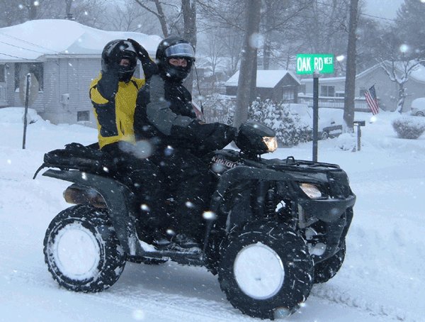
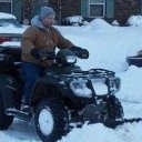
      I have a Sportsman 450 HO and almost killed my self when loading it on my truck with ramps.  It rolled off the top of the ramps and tailgate and nearly landed on me.  I now want to winch the ATV in to the truck.  My question is are the front side bed tiedowns in my 2011 RAM strong enough to winch to without distorting the hooks or sides of the bed?
    • By BuckBilly
      I like to ride in wooded and grassy areas. It takes my mind off the everyday routines and helps me deal with my father's cancer. Also gives me a reason to get involved with forums like this one.
×
×
  • Create New...